Why Google Earth is not enough for photovoltaic planning
Beware of inaccurate PV planning without drone technology.
Some photovoltaic providers rely on Google Maps and Google Earth for their PV planning. We are seeing more and more often commercial properties being completely covered with PV modules and the distances to the lightning protection—as well as the safety distances between the edge of the roof and the safety edges—being ignored. Both can have devastating consequences.
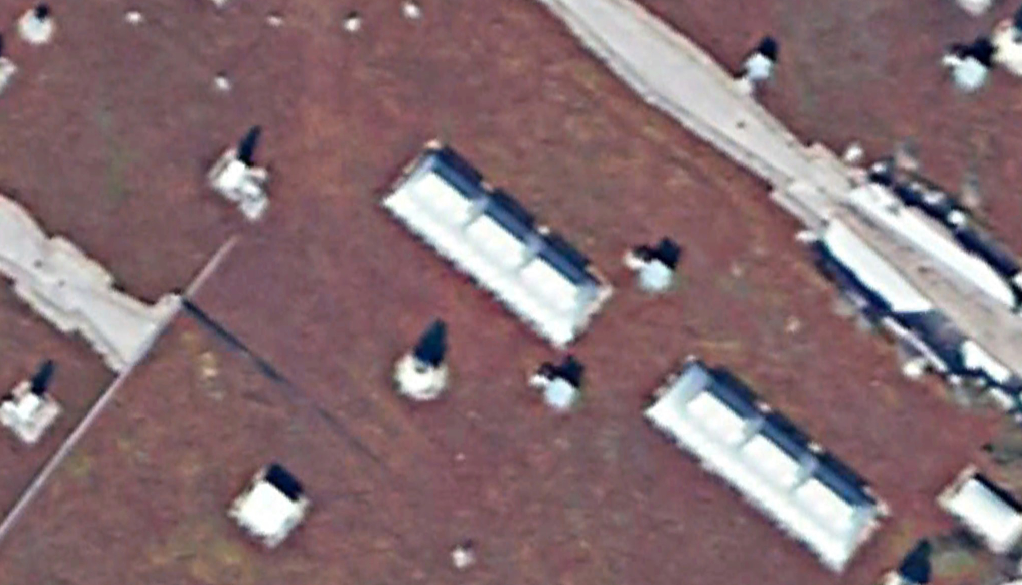
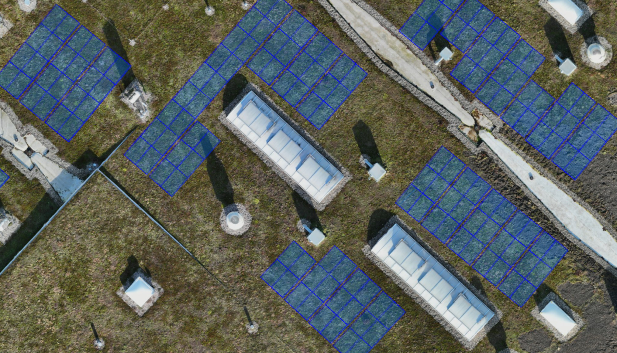
Picture above: Comparison between an image of a building, created with Google Earth (left) and with a drone (right)
Is Google Earth suitable for photovoltaic planning?
Yes, for rough planning, but drones are essential for precise planning.
Google Earth is a useful tool for the initial rough planning of photovoltaic systems, but it has some limitations that make it less suitable for detailed and precise planning:
Limited resolution: The resolution of satellite images in Google Earth can be limited. However, for precise planning of solar installations, you need high-resolution images to see details such as shadow penetration, slope of the terrain, obstacles ,and the exact shape of the roof or property. Drone images often offer a much higher resolution than satellite images.
Actuality of the images: Satellite images in Google Earth can be out of date. When planning solar installations, it is important to have the most up-to-date data to be able to take into account changes in the environment, as they could affect the performance of the system. Drone imagery can be updated in real time or at least at shorter time intervals.
Limited perspectives: Google Earth usually only offers a limited number of viewing angles. When planning solar installations, it is important to view the terrain from different angles to determine the best placement of the modules. Drones can photograph from different heights and angles, which allows for a more comprehensive analysis.
Missing terrain data: Google Earth often does not provide accurate terrain data such as elevation profiles, which are critical for determining the optimal tilt and orientation of solar panels. This data is important to maximize the yield of the system and minimize shadows.
Overall, Google Earth is a good first step for a rough idea, but for the detailed planning and optimization of a professionell photovoltaic system, specialized tools and high-resolution, up-to-date data, such as that provided by drones, are essential.
What alternatives support photovoltaic planning?
Modern drone technology
Fast & precise data capture: Drones can provide high-resolution images and videos from different angles. This data is extremely useful for creating accurate maps of the terrain, including any obstacles such as trees or buildings. This precision is important to determine the optimal location for solar panels to get maximum sunlight.
3D modeling: 3D models of the planned solar installation can be created based on the data collected by drones. This allows planners to visualize the system virtually and run through various scenarios before the actual installation begins. This allows them to better decide how and where the panels should be placed in order to maximize the yield.
Increased efficiency: In the past, surveying a site to plan a photovoltaic system required a lot of time and resources. Drone technology makes it possible to speed up this process considerably. Large areas can be precisely surveyed and analyzed within a short period of time, reducing time and costs.
Inclination & orientation: The inclination and orientation of solar panels are crucial for their efficiency. Drones can provide accurate data about the terrain, allowing planners to determine the optimal tilt and orientation for the panels. This maximizes the energy production and profitability of the installation.
Inspection & maintenance: After installation, drones can also be used to inspect and maintain the solar installation. They can quickly check for possible damage or problems without the need for physical access to the panels. This saves time and costs for regular inspections.
Overall, drone technology therefore helps to optimize the entire process of photovoltaic planning, from site investigation to installation, and maintenance.
How does Luana AG plan photovoltaic systems?
Automated drone technology paired with professional project management
At Luana AG, we work in a highly structured manner in our PV planning and place the highest value on professional project management. All our planners have a so-called „large“ drone license (A1, A2, and A3). We train them ourselves and ensure that they successfully pass their exams so that they can carry out precise, highly professional planning. They develop our PV systems in collaboration with our project managers.
- All our planners have a „large“ drone license (A1, A2, and A3)
- All our project managers are PRINCE2® certified
- Work with state-of-the-art, automated drone technology (accuracy to 2 cm)
- Work with market-leading project management tool (incl. Gantt chart planning)
- Professional 3D modeling and simulation of the PV system
We also take the following points into account in our planning:
- Lightning protection concept
- Fire protection concept
- Grid connections
- Power distribution
- Statics
Ready to go green?
Contact our experts now.